My adopted city of Saint Louis has increasingly been the focus of national media in the past six months. While coverage formerly focused on Saint Louis being designated as America's Most Dangerous City in 2006 or dwelled on the sordid tale of Michael Devlin. Compared to these stories almost anything would seem an improvement, especially for a city with notoriously low civic esteem. While a lack of vision and regressive attitudes still constitute the largest challenge to Saint Louis, the view from outside has begun to change markedly.
Saint Louis CityGarden -- a project by the Gateway Foundation designed by Nelson Byrd Woltz. Photograph by author.
City Garden, the most significant improvement to the city of Saint Louis since the restoration of Forest Park, and like Forest Park, is an extremely positive example of the utility of public/private partnerships in the face of diminished local planning. City Garden has received glowing reviews in a number of sources from parenting and travel magazines to industry publications. East West Gateway's Great Streets pilot program on South Grand has provided momentum for a sorely overdue assessment of the urban design of commercial corridors in the city and provides a vision for a move away from the strict prioritization of single-occupant automobile transit on city streets. While the trial narrowing of Grand has gotten the most attention, the participatory process leading to the proposed option set an excellent local example by combining education with participation.
Perhaps it was the growing national recognition of a changing attitude that brought Next American City to St. Louis for a conference. I was honored to be invited to participate on a panel of emerging voices in the Vanguard Regional Roundtable. As Michael Allen has noted, the Next American City conference was fated to be in both chronological and philosophical opposition to another event: the hearing on the McKee NorthSide TIFF request.
The latest public exposure is perhaps the most striking: Richard Layman, author of Rebuilding Place in the Urban Space is examining St. Louis Metro's Moving Transit Forward planning campaign. As a transplant to St. Louis I find the transit issue infuriating. While most outsiders will readily admit that both the St. Louis Metrolink light rail system and MetroBus system is effective and even unexpectedly good for a city of St. Louis's resources, the local perception is that public transportation here is defunct, unworkable, and that ownership of an automobile is essential for daily life. At a recent conference on urban issues Alvin Reid, editor of the St. Louis Argus compared the MetroLink to a toy. As an example of a functional system he pointed to Washington's metro system.
This is exactly what makes Layman's post so interesting. The subtitle is "St. Louis regional transit planning process as a model for what needs to be done in the DC Metropolitan region." Layman focuses on the efforts of metro to educate the public as part of the process. This is a long overdue effort. In hindsight it was poor communication and an inability to justify the importance of Metro funding that doomed last year's Proposition M. In a vacuum of information it ceased to be an initiative on badly needed expansion, and instead became a referendum on past problems. Metro must take an active role in justifying its importance to the region and in educating residents. To echo Layman, another needed step would be to clarify the subsidization of automotive transportation to eliminate the transit-welfare stigma. Despite the antipathy towards transit frequently evidenced here, it is gratifying to know that Metro's ambitious and inclusive new initiative is at least recognized outside of the Mississippi valley.
For the first time in years Saint Louis is receiving noteworthy attention on the national stage. With attention comes increased expectations. We must build on the foundation of participatory involvement and education evidenced in the best projects of this past year, reject negativity and insecurity, and advocate for a city that can once again serve as an example to the region and to the nation beyond.
Part one of this essay examined the rise of the cemetery in the western world and considered the relationship of cemetery to urban form. This passage considers the effects of changing attitudes on the traditional cemetery and attempts to uncover the potential benefits of rethinking the cemetery. Cemetery at the edge of Romney, West Virginia by John Vachon for the FSA.
Cemeteries stand in cities throughout the world as memento mori -- monuments reminding us of our own mortality. Intensely loaded with religious symbology and cultural allegory through their design, these places often represent the values of a place most clearly. The character of the cemetery runs the gamut from touching intimacy to cold and unsettling monumentalism. Whatever the scale, however, the immense labor needed to build and maintain cemeteries is always owed to the eternal human desire to be remembered after death. Whether this desire for immortality represents mankind's philosophical need to detach from natural processes remains debatable, but it has led to the development of an architecture that outlasts culture and it is the cause for the underutilization of significant tracts of land today.
Throughout the twentieth century there have been frequent calls to re-envision the methods and rituals with which we take leave of our dead. The most significant shift has been the gradual progression towards acceptance of cremation. While we take this method for granted now, it has only become an option within the past fifty years. Many of those who crusaded for cremation saw it as a more dignified method of interment. As the twentieth century began, popular culture became obsessed with strategies of mummification and preservation which have continued into the current interest in cryogenic freezing. As Unitarian Rev. Thomas R. Slicer was quoted in a 1921 study by S. Adolphus Knopf1:
“Nothing seems to me to be a more direct affront to nature than hermetically to seal up a human body and then place it in the ground, as though one defied nature to have access to which belongs in it: -- Unitarian Rev. Thomas R. Slicer in Knopf, S. Adolphus. “Cremation Versus Burial--A Plea for More Sanitary and More Economical Disposition of Our Dead,” New York: American Public Health Association, 1921.
This statement marks an early challenge to the egotistical desires to preserve human remains in perpetuity. If mortality has proved incompatible with productivity driven modern culture, then cemeteries exist as a precarious third space.
Beyond the effect that cultural changes have had on cemeteries, modern life also conspires to reduce their importance. As globalization has increased mobility, the bond between the living and their ancestors is frequently severed by distance, time and culture. The historical ideal of a cemetery is represented above in the image by John Vachon; cemeteries were steeped in place and personal history and represented an axis mundi between settled inhabitants and their ancestors. With a distinct minority of the population entertaining any expectation of spending their lives near their birthplace cemeteries cannot fulfill the same social role they once did. The extreme result of mobility has been frequent abandonments and derelictions of burial grounds as descendants lose touch and funeral societies die off. 2. Headstone at Old St. Marcus Cemetery Park, St. Louis. Photo by author.
In addition to the dereliction of cemeteries, widely dispersed cemeteries decentralize land use and facilitate sprawl. The difficulty of assembling urban land forced the modern cemetery to the periphery of urbanized areas. Today many cities are constrained by a noose of cemeteries and floundering golf courses. In St. Louis County both cemeteries and golf courses were developed outside city limits along interurban streetcar lines for ease of access. This has led to a clustering of such facilities near St. Charles Rock Road and along Gravois/Hampton. Many of these cemeteries are faltering and several have been cited for questionable practices or have fallen into default. The most striking example of this phenomenon is Old St. Marcus cemetery at 6638 Gravois Rd. Old St. MArcus was founded in 1856 by the congregation of the St. Marcus German Evangelical Church. Only around 3,000 of the 19,500 burials were provided for under perpetual care. The cemetery was succeeded by New St. Marcus cemetery in 1896 and was defunct by the 1950's. It was abandoned for almost thirty years leading to intense vandalism, crime, and rumors of grave robbing. By the late 1970's the weeds in the cemetery was completely overgrown and the city seized it for a park. What few headstones were left were stacked into walls and the grounds today are an eerily empty park punctuated by remaining gravestones that frame views of an adjacent public pool. Old St. Marcus Cemetery Park. Photograph by author.
As Julia Levitt wrote at Worldchanging.com: "The next time you're waiting at an intersection, look around and imagine how much of the built (and furnished) environment stands empty and unused at any given time.”3 This examination should be applied to all land uses. Can we devise alternative uses for these overlooked cemetery spaces? Can we reutilize them or redevelop them to spur greater density and increase transit feasibility outside urban cores and in postwar suburbs?
The next part of this series will deal with a vision for redeveloping cemeteries as part of a sustainable infrastructure network.
No earthly state stands less fickle, As with the wind that waves the wicker, So waves this world's vanity--
Fear of death unsettles me. ... Unto the Death go god's estates, Princes, lawyers, Heads of state, Both rich and poor in all degrees--
Fear of death unsettles me.
--Joe Scanlan, "Lament for the Makers"
Headstone at Greenlawn Cemetary, Columbus, Ohio.
This is the first part of a three part series that will focus on cultural/spatial responses toward death, the tenuous position that cemetery ritual has in modern culture, and a radical rethinking of burial practice as sustainable infrastructure.
Part One: The Emergence of the Cemetery
Burial grounds stand in cities throughout the world as memento mori or monuments reminding us of our own mortality. Intensely loaded with religious symbology and cultural allegory through their design, these places often represent the values of a culture most clearly. Originally intended as places of mystic ritual, burial grounds are the spatial reification of humanity’s struggle with that which lies beyond understanding.
Before the modern area burial grounds served as an anchor of community. People were born, families were created and members died within eyesight of their place of worship. In the western world the church graveyard served as an extension of the home. The church graveyard was so expropriated by its living constituents that “the church finally had to forbid such activities as gambling and dancing within cemeteries”1.
That such an idea seems alien to the modern observer is a result of the massive cultural shift in the modern age. In the seventeenth and eighteenth century numerous church graveyards had begun to give way towards organized cemeteries in many European cities. These early cemeteries were orderly necropoli containing a grid of small mausoleums where the dead were interred in an urban environment resembling that in which they lived their lives. Such cemeteries are rare in this country. The best examples can be found in New Orleans, which as a far outpost of France did not witness the post-revolutionary cultural change that the motherland did.
Lafayette Cemetery Number One, New Orleans, Louisiana.
After the French Revolution, the strict rectilinear order with elite districts of ostentatious interment was believed to represent the ancien regime. Those that laid out new cemeteries sought a more egalitarian design and looked to the culture of rural laborers for a new order. As this type of cemetery was built in England and the United States, this practice coalesced into a structured reinterpretation of a pastoral landscape. While such cemeteries strive to seem untouched idylls they harnessed the very latest engineering and hydraulic innovation to reshape the landscape.
As a result of their bucolic appearance cemeteries assumed the public life that once characterized the church yard. In the high Victorian area cemeteries, like asylums, were not seen as places of difference, but rather served as needed islands of nature in industrial cities. It was common for families to travel to the cemetery or asylum grounds for weekend picnics or recreation. Such practices led to efforts to create publicly accessible parks. Despite their popularity, cemeteries still were redolent of human mortality, and, as the nineteenth century ended, parks displaced cemeteries as grounds for recreation.
The idyll of death: landscape at Greenlawn Cemetary, Columbus Ohio.
While cemeteries were seen primarily as places of recreation that would provide religious and moral instruction in Victorian times, these sentiments have become incompatible with modern lifestyles. "There is no available ideology to integrate them comfortably into the rhythms of the metropolis."2Cemeteries have again changed to reflect current culture. While burial once emphasized the deceased’s ties to kin with demarcated family plots, ornamental fencing, common design, and often communal monuments, modern monuments seem designed to accentuate the individual. The landscape has become an unsuccessful hybrid of the idyllic and the Euclidean with a gridded aggrandizement of individuality overlaid over an impotent derivation of a depoliticized peasant landscape. Furthermore, the loss of the cemetery as communal space has also led to the relegation of the dead to the margins of society.
In the premodern area, through shared ritual and spatial proximity the dead were allowed to exist within society. Today, disease is viewed from the lens of unproductivity, and death is the anthesis of the productive life that defines success. Our culture banishes death to the margins and refuses to contemplate its meaning, for “In a society that officially recognizes ‘rest’ only in the forms of inertia and waste, death is given over for example. to religious languages that are no longer current, returned to rites that are now empty of the beliefs that once resided in them”3. Today cemeteries exist as dualistic monuments: monuments to the desire of eternal memory in the face of death and monuments to the practices and customs of our ancestors.
Modern headstones contrast with empty attempts at romantic landscapes, Laurel Hill Cemetery St. Louis.
Works Cited in this Article: 1 Kearl, Michael C. Endings: a Sociology of Death and Dying. New York: Oxford University Press, 1989. p. 50. 2
2. City A-Z. Ed. Steve Pile and Nigel Thrift. New York: Routledge, 2000. p. 92.
3 De Certeau, Michel. The Practice of Everyday Life. Berkeley: University of California Press, 1988. p. 192
Coming Soon: Part 2: The Psycho-spatial disconnect of Modern Cemeteries
Via Baltimore Inner Space blog comes an interesting approach to participatory redevelopment. I have quoted Paul Davidoff's assesment of participatory planning in an earlier post: "Lively political dispute aided by plural plans could do much to improve the level of rationality in the process of preparing the public plan."
This level of lively discourse is often exceedingly difficult in developer driven projects where significant monies have already been invested. In many cases the illusive veil of a public participation process may be used to control and appease the opposition. The manipulation of statistics derived from resident surveys works to a similar end. These abuses continue to occur because the financial stakeholders of the new plan feel threatened by the efforts of resident and community members to challenge decisions. The often beneficial act of initial investment becomes the stumbling block for participation in the process.
While participatory planning processes began in the 1960's due to the enormous impact of Jane Jacobs's The Death and Life of Great American Cities (Modern Library Series) and Davidoff's work, it rarely transcended a reactionary methodology. Some efforts did begin as the result of resident groups lobbying for improvements, but most public participation existed due to legal mandate or as a reaction to proposed developments.
While it might be dismissed as utopian to reverse the equation to emphasize proactive community participation and reactive development, such a process would have strong advantages. The community would become the major source for ideas and inspiration and developers would vet such proposals for economic feasibility. The major advantage for such a procedural change would be the Collective Intellegence available to developers by utilizing the community as an open-source network of proposals and focus groups. While this concept seems radical, it is currently the primary advantage between of design competitions and charrettes.
Even if one remains decidedly skeptical of a technologist viewpoint it remains impossible to ignore the impact that social networking and internet-based communication has had on activism in the last decade. While the power of such technological advances was aptly demonstrated in the last presidential campaign, urban professionals are using such methods to create coalitions and advocacy organizations that may reshape local planning organizations in the decade to come.
One example of effective citizen activism is the 8664 project in Louisville. 8664 seeks to prevent a massive and illogical 23 lane highway interchange expansion on Louisville's riverfront. Furthermore, this 10,000 member grassroots organization has proved that by replacing the proposed two bridge/multi-lane expansion with a single bridge and an urban boulevard their plan will save billions of dollars, improve on a civic amenity and retain 99% of the traffic efficiency of the government's proposed plan.
While 8664 is a case study for the organizational power of new technology and is an example of the current state of many civic-powered development advocacy organizations, The Baltimorphosis proposal for the Franklin-Mulberry corridor in Baltimore shows the full potential of technology to revolutionize participatory planning. The Franklin-Mulberry corridor is a unfinished urban spur freeway through some of the most abandoned and underdeveloped neighborhoods in Baltimore. Baltimorphosis seeks to replace the existing highway trench with a combination of light rail, commuter rail, an urban boulevard and multi-story development. By developing construction within the ditch larger 4-6 story buildings can be visually accommodated in a predominately 2 story rowhouse area.
A more intensive scheme involves capping light rail and commuter rail lines and creating a large multi-story parking garage in the remaining highway right of way with new construction on the surface.
The difference between Baltimorphosis and other similar civic proposals is the incorporation of open-source design. The images above come from dimensionally accurate 3-D sketchup models which can be downloaded and reworked by interested members of the public:
You can submit designs in a variety of formats, including straight Photoshop. Humorous ideas are okay, but we prefer ideas that have some bearing on the real world. Model 2 to the right is a good starting point if you like to work in 3D. The blue and brown buildings are just placeholders that you will replace. If you have are more comfortable with 3D modeling, you might start with Model 1, an existing two-block section of the highway ditch, which is more of a blank slate. If enough people apply their brains to this challenge, the results will prove that Franklin Mulberry has too much potential to let slip away. If you're really ambitious, you can take a stab at the Ice House or Social Security districts at the West and East ends of the corridor by downloading Models 3 and 4. Whatever you do, send us images of your designs so we can post them to our Gallery section. Send your name and occupation if you like, but that's up to you -- taken from baltimorphosis.com
While this degree of public involvement is excellent for generating a vast array of proposals, it also works to build a wide coalition of citizens who can pressure government for a better solution.
Compare this process with the process that resulted with the aborted construction of the highway. In that case, a technologist bureaucracy implemented a massive plan resulting in the demolition of hundreds of buildings and the destruction of a neighborhood. There was little civic participation and the planning took place using aerial maps behind closed doors. Today technology gives us the chance to work experientially in three dimensions and to consider hundreds or permutations of a design while utilizing the practical knowledge of residents. In effect a proactive participant planning process initiates the "lively political dispute" and will "improve the level of rationality" before development... a practice Paul Davidoff anticipated forty years ago.
The current recession was unforeseen by all but the most thoughtful and careful investors, but many effects of the recession are predictable. The average individual has drastically reduced spending in favor of savings as reflected in the downward spike of the Personal Consumption Expenditure metric and the converse increase in the Personal Savings rate to 4.2%; this rate marks an 11 year high.
The primary physical manifestations of these trends include a turn away from luxury retailers to discount superstores, the emergence of the ridiculous "recessionista" trend, and a significant decrease in vacation plans. More interestingly, some cultural pastimes recently relegated to nostalgia are once again becoming popular. One blog lists 67 Cheap Date Ideas for the Recession-Era Romantic. The general flavor of the cultural swing can be drawn from the following suggestions:
Browse the local farmers’ market. Go on a picnic. Go apple picking. Attend an open-air festival. Attend an art gallery. Pick up a movie at your local library. Go window-shopping. Watch Shakespeare in the Park. Skip rocks at a lake. Take dance lessons at a local community center.
Consider what kind of reaction might have been expected to the activities on the above list as few as three years ago. What is striking about these activities is not their affordability, but the extent to which they utilize public space and amenities as the setting for recreation and socialization. It seems that the economic recession has singlehandedly revived the recently moribund concept of public space. In locations where parks, plazas, and playgrounds already exist creative programming can help to attract residents and provide a civic amenity.
Unfortunately in the current situation the funding streams for many of these programs are drying up and beleaguered city and state governments typically do not prioritize civic amenities. However, maintaining such programming to support a civic life has positive tertiary effects on everything from crime to property values. As Noah Kazis argues:
These events are not about “quality of life” in terms of concrete provision of goods or services. These kinds of events are valuable only because they are about building local community, real or imagined. In some places, these events are at the local enough level that you see the neighbors you know and the ones that you should get to know in a friendly environment. ... Building these communities is important. Community cohesion is important for keeping down crime, for fostering local businesses, for all sorts of things. Intuitively, I think everyone knows that when you walk into a vibrant community, as opposed to just a neighborhood, you know instantly it’s a place you want to be.
The development of a vibrant and civic minded neighborhood is the definition of sustainability. Many important figures have noted that citizen participation is the bedrock of a sustainable pattern of urbanism. Once initially educated on core concepts of sustainability, residents are best equipped to devise and propose new initiatives, and it is this civic engagement that has contributed to the success of significant projects.
Clearly the cultivation of civic engagement and vibrant urban spaces is important. The irony of the current blossoming of interest in urban civic space is that the same economic conditions that instigated this cultural shift also curtail government spending. In the current economic climate quality of life projects unfortunately take a back seat to other more pressing concerns. This does not have to happen. Most civic projects focusing on public spaces concentrate on large visions of redevelopment.
Vibrancy can also be built from a number of inexpensive tactical incisions into the urban fabric. After all, small projects can turn urban space into an urbanism of the scavenger hunt to encourage walking, which in turn stimulates small businesses.
I have gathered five techniques to reinforce public space to inspire everyone to take up the cause of guerilla urbanism. These are presented in order of least to most expensive.
#1: Poster Pocket Gardens. Artists Sean Martindale and Eric Cheung used the existing posters plastered on building sides and utility poles as a container for public greenery. This method has some promise for an urban-scaled plant sharing cooperative. Sprout extra seeds? Just leave them on the corner telephone pole! Poster pocket plants in Toronto (via Spacing Toronto).
#2: Crack Gardens. Although this project by CMG Landscape Architecture was a formal garden design for a residential property, it points to a tactic to be used on crumbling streets and alleys of urban areas. Such gardens could also help to limit stormwater pulses by absorbing rainwater and limiting runoff.
Crack Garden by CMG Landscape Architecture (via Pruned).
#3: Garden Sharing. OregonLive reports on Alice Lasher and Sue Decker who have begun sharing gardens and trading produce for labor. Their garden extends over property lines and along parking strips by the street. Expanding personal gardens to the neigborhood scale produces community interaction and results in a concrete benefit: good produce from underutilized land. TH - Best Front Garden Produce by szcze.
#4: Temporary PARK(ing). The Rebar art collective in San Francisco deployed the initial PARK(ing) intervention on November 16, 2005 from noon until 2 p.m. Visitors enjoyed the turf and took turns paying the meter. Since then the phenomena has taken off into a network and numerous deployments have taken place across the United States. While the construction of this type of intervention is moderately expensive, the iconic image and ease of transport make it a great anti-car advocacy tool. PARK(ing) Project 2005 iteration (via Rebar).
#5: Dumpster Diving. Reminiscent of a cross between Ken Smith's Dumpster Gardens and the old Situationist slogan "Beneath every paving stone, a beach!", this project by MACROSEA in Brooklyn only took 12 days to build. Like the PARK(ing) project, this concept could be a significant tool to revitalize places with a dearth of public amenities. Furthermore, this project suggests ways to deploy significant civic infrastructure using readily available materials on a small budget.
In the first article I compared the Loop Trolley project to a streetcar project in Columbus, Ohio:
"...the Loop Streetcar connects an already developed area (named one of America's 10 Greatest Streets in 2007 by the American Planning Association) with Forest Park and would run a mere two and one quarter miles. Of this length, only around eight blocks have any potential for the streetcar to serve as a catalyst for significant redevelopment. The Columbus proposal would have been greater than five miles in length, would have connected five distinct economic centers and could have provided the catalyst for over thirty blocks of undervalued property."
My contention is that the Loop Trolley should not be envisioned as a tourist attraction as it is now, but should be understood to be the start of a restoration of an effective surface transit network and as an engine for incremental growth.
"Cleveland’s [St. Louis's] leadership has no apparent theory of change. Overwhelmingly, the strategy is now driven by individual projects. These projects, pushed by the real estate interests... confuse real estate development with economic development. This leads to the 'Big Thing Theory' of economic development: Prosperity results from building one more big thing." - Ed Morrison, "Cleveland: Reconstructing the Comeback" via The Urbanophile
St. Louis, like many mid-sized cities, represents Morrison's assessments of Cleveland to a tee. The influential industrialists that motivated major changes a century ago are gone. Names like Wachovia have replaced the financial firms that outlasted the demise of industrial powerhouses like the St. Louis Car Company or the American Stove Company. Other powerhouses such as Anheuser-Busch have been sold overseas. As the Urbanophile describes, transactional businesses such as real estate have completely replaced the industrial/commercial ogliarchy of old. Thus, real-estate development is conceptualized as economic development, and the major infrastructural improvements that could drive the development of revitalization and attract the necessary workforce for innovation are sacrificed for strip malls, warehouses, or failed commercial redevelopments.
The political and economic situation bears striking similarities to Paul Collier's assessment on post-conflict recovery:
The first principle is, it's the politics that matters. So, the first thing that is prioritized is politics.
[Development should proceed in the most apolitical way possible. Decisions should be made with the entire city and region in mind, not for one ward at the expense of another or one region at the expense of another.]
And then the second step is to say, "The situation is admittedly dangerous, but only for a short time."
[Development decisions should be made with a view towards fostering sustainable growth and future development, not through short-term job creation and TIF-baiting]
And thirdly, what is the exit strategy for the peacekeepers? It's an election. That will produce a legitimate and accountable government.
[Development (especially infrastructure development) should be freed from electoral cycles and the control of aldermanic discretion]
So that's the conventional approach. I think that approach denies reality. We see that there is no quick fix. The reality is that we need to reverse the sequence. It's not the politics first; it's actually the politics last. The politics become easier as the decade progresses if you're building on a foundation of security and economic development. The rebuilding of prosperity.
Why does the politics get easier? And why is it so difficult initially? Because after years of stagnation and decline, the mentality of politics is that it's a zero-sum game. If the reality is stagnation, I can only go up, if you go down. And that doesn't produce a productive politics. And so the mentality has to shift from zero-sum to positive-sum before you can get a productive politics. You can only get positive, that mental shift, if the reality is that prosperity is being built...
But the objective of facing reality is to change reality. --Paul Collier "New Rules for Rebuilding a Broken Nation", 2009. (emphasis and bracketed comments added)
In the interest of changing reality, I will show how extending the Loop Trolley beyond Joe Edwards's vision could begin to act as an economic driver for urban redevelopment and could be leveraged in subsequent phases for future growth.
Phase I: 2015 Changes to proposed route: Light Blue Beginning with the initial route proposal, I examined the street widths along the route and efficiency statistics from several cities. The Loop Trolley is currently planned to occupy two traffic lanes (two way traffic) on Delmar through the Loop. At this point Delmar is only 48' wide and Loop Trolley planners intend to retain two lanes of street parking. Note that Portland's Streetcar System Concept Plan predicts an average speed of 7 mph riding in traffic. By comparison, a streetcar in a median right of way will typically achieve a speed twice as fast.
In order to facilitate a separated right of way, the streetcar has been routed to run westbound on Delmar, looping around to Kingsland via Loop S. The streetcar would the head north on Kingsland before heading eastbound on the Vernon Ave. Loop bypass and would rejoin Delmar at the MetroLink station (Des Peres Ave.).
This route would have other benefits beyond merely increasing line speed. The eastbound routing on Vernon follows the #2 Bus and would connect the 1,500 residents in the Parkview Gardens neighborhood with the MetroLink station. This proximity to transit would also spur redevelopment of the underutilized commercial strip along Vernon between Kingsland and Westgate.
Amendments to proposed route: Light Blue The two major problems with the existing route are that the History Museum is not a strong enough draw for a terminus, and it does not service any major job centers. In the turn of the twentieth century streetcar companies addressed this issue by building amusement parks at the end of their lines to draw more traffic.
To solve this problem, I proposed extending the route on Delmar to the Central West End and looping around the West End. While the Olive streetcar originally ran in a zigzag west from McPherson to Waterman (at Kingshighway) to Pershing (at Union), Delmar is an excessively wide boulevard with ample width for two dedicated and separated tracks. The CWE loop would take advantage of the wide median on Kingshighway to loop south to Laclede (within easy walking distance of the Barnes Jewish/Wash U/Children's hospital complex) and then continue on Buckingham (reversed one way from present) to North Ct./York Ave. and then through the heart of the CWE on the old Maryland #12 Streetcar ROW. The loop would then follow that ROW left on Boyle and turn westbound at Delmar.
Besides connecting an estimated 26,000 employees at the hospital with numerous commercial businesses in the Loop and the CWE, this alignment would provide a major impetus towards redevelopment on the north side of the CWE. Over 14 blocks of underdeveloped land would see an increase in value and the streetcar would provide considerable assistance to redevelopment efforts in the former Gaslight Square area. This route, around seven miles in length, would require more route investment, but would not require additional carbarns or maintenance areas. Such an extension would drastically increase boarding and would secure the viability of the Loop Trolley proposal.
Phase II: 2020: Green Pending successful operation of the Delmar Loop/Central West End, an expansion could be easily planned along the former Olive St. ROW and McPherson/Washington. This expansion would be a compact figure eight meant to connect the Delmar Loop/Central West End with the museums and entertainment facilities in Grand Center. The figure eight would run as a spur from the CWE route during designated hours. The estimated time on the extended original line from City Hall in University City to the Fox theater would be 25 minutes.
At the same time construction would begin on the reinstallation of the #70 Grand streetcar line between a loop opposite John Cochran VA hospital to a loop just north of Grand and Gravois. This section would completely follow former streetcar right of way and be able to run in a dedicated median as a result of the wide street width.
This route would replicate one of St. Louis's most used streetcar routes and would connect the VA Hospital with Saint Louis University Hospital, and the cultural institutions in Grand Center with the populations of both University City and the near south side. The CWE extension could bring more redevelopment on the eastern fringes of the Central West End and both routes provide valuable support to the nascent efforts of the Locust Business District.
Phase III: 2025: Yellow Phase III would include a Washington Avenue/Olive Street line that would run from the Blue line loop east of Grand through the loft district to Laclede's landing and the Arch MetroLink station. In addition, a new line would be built running south on Florissant from Palm St. through downtown on Tucker with a connection to the 14th St. Greyhound/Amtrack/MetroLink station, and south on Gravois to Grand.
The Washington/Olive route would provide economic support for the underdeveloped areas between Grand Center and the Loft District and would integrate the faltering entertainment district at Laclede's Landing with downtown institutions such as the Convention Center. The Florissant/Tucker/Gravois route would connect some of the most densely populated areas of the city with jobs downtown and with other necessary amenities while spurring redevelopment in St. Louis Place and integrating Old North St. Louis with downtown.
Phase IV: 2035: Purple Phase IV would include an extension on the #70 line north from the VA Hospital to N. Florissant Ave, an extension south on the Gravois line from Grand to Germania St, and a line on Natural Bridge from the UMSL South MetroLink stop to Palm and North Florissant.
These routes would leverage existing streetcar routes and would connect with existing transit corridors. Furthermore these routes would tap into dense population centers in the city and would facilitate small scale economic and storefront redevelopment.
Phase V: 2050: Brown The final planned phase would consist of three lines along former streetcar routes. A Goodfellow/Union/Hampton line would connect from the Riverfront transit center to Forest Park and the end of the Gravois streetcar in far south city. A Martin Luther King/Cass Avenue streetcar would provide an East/West connection on the near north side from the St. Charles Rock Road MetroLink Station to downtown. A Broadway/Chippewa line would connect the Cass Ave. line through downtown/Soulard and south city to the Shrewsbury MetroLink station. While it is too far in the future to prognosticate development potential, this line could provide a great development impetus to the neglected industrial land along the south riverfront.
While this was an intellectual exercise, it emphasized some key lessons. First, any proposed transit as expensive as a streetcar line must serve a vital connection need and must connect key employment destinations. Cultural destinations are important draws, but major employers are vital. Secondly, while there are parts of the city that suffer from a lack of transit, the best route is an already successful route. More revenue upon opening will provide a greater impetus to expand the system. Finally, due to the era of development in St. Louis, the built environment and infrastructure was specifically designed for streetcar-based transit and a considerable amount of infrastructure remains to this day. Therefore, implementation is not as difficult as in other cities.
There was recently an interesting article on anti-urban media bias from Greater Greater Washington, a blog focusing on urbanism in Washington DC. Dissecting the Washington Post coverage of Fairfax County Virginia's proposed incorporation as a city, the blog emphasizes how the article's authors repeatedly use codewords for city such as "blight" and "crime". Furthermore, they revealed their biases in an illustration of the difference between a city and a county through an explanation
"which juxtaposes suburbs ‘where Washington goes to walk the dog and water the lawn’ with something ‘many have tried to avoid: high-rise offices, blight, crime and housing that's more likely to have a balcony than a back yard.’"
. While this is an egregious and perhaps malicious example of anti-urbanism in reporting, many other examples can stem from overly sensational reporting or from the natural biases caused by a set lifestyle. For example, since reporters presumably represent an average cross-section of the american population, it is not unreasonable to assume that few reporters walk or bike to work. Thus, the act of driving colors their view of the world and that coloration inevitably seeps into their writing.
There are, however, some stories that are so ridiculous as to overwhelm whatever personal urban or anti-urban bias a reporter might have. The events of May 15th in Saratoga Springs, New York are one such event. Andrew J. Bernstein reports the events occurring on National Bike to Work Day:
Janette Kaddo Marino and her son, Adam, 12, wanted to participate in the commuting event, so the two set off to Maple Avenue Middle School on bicycles May 15. The two pedaled the 7 miles from their east side home, riding along a path that extends north from North Broadway straight onto school property.
After they arrived, mother and son were approached first by school security and then school administrators, who informed Marino that students are not permitted to ride their bikes to school.
“Unbeknownst to us there is a policy,” she said, “but it wasn’t in any of the brochures given to us.”
School officials took her son’s bike and stored it in the boiler room. They told her she would have to return with a car to retrieve the bike later in the day.
I will ignore the possible legal ramifications of illegal seizure of private property and examine the school environment. Maple Avenue Middle School, like the vast majority of educational facilities in the country, is built on the periphery of Saratoga Springs. While this location presumably made consolidation easier and facilitated a larger athletic complex, it put it out of easy reach for the majority of students.
Maple Avenue Middle School in relation to Saratoga Springs. View Larger Map
Maple Avenue Middle School aerial.
The school was built in 1992 on busy US Route 9 (Maple Avenue--bucolic in name only) to facilitate bussing students not only from the city, but from the suburban developments ringing the former resort town. Two years after the school was built the school district issued Transportation policy No. 741 forbidding students to ride or walk to the school.
The school was designed to accommodate 1,800 students (in a middle school-- that averages to around six hundred students per grade!) divided into four sub-sections, each named for one of the Saratoga Springs Lakes. The school, from the aerial is all but indistinguishable from a minimum security prison and the urban design reinforces the idea of containment. There is no clear path to the entrance and the school sits nearly a hundred feet back from the road behind parking lots. Route 9 is atypical of high-traffic rural routes, despite being an undivided two way road, it does have ample shoulder room at least a lane wide. This is immaterial however, the route Mrs. Marino and her son took was on a quiet neighboring street that dead-ends into the school property.
The principal, one Stuart Byrne, explained that the prohibition on self-transportation to school is, of course, designed to protect students:
“I would be a nervous wreck every day if kids were riding to school,” he said. “Traffic isn’t bumper to bumper, but it’s non-stop. He said the district’s policy does not allow students to ride or walk to schools outside of the city’s urban core.
While traffic is one concern, Byrne said he also worries about children traveling unsupervised through the community. He noted that students are under school supervision until they are dropped off by the bus or picked up at the end of the day.
“If you look at the North Broadway route that the parent used that day: (Even if) there were going to be some exceptions or monitoring (to allow riding to school), you’re still going into a substantially wooded area,” he said. “I don’t know how you say to the community at large that is a safe area.”
In one statement the principal has raised every parental boogeyman from traffic accidents and abduction to fear of the wild to substantiate the need for continuous monitoring and control.
Of course, the public health implications of policies that prohibit walking and riding are not considered. According to Dr. Richard Jackson, one third of children born in the past year will contract Type II Diabetes if current trends continue. The Centers for Disease Control just reported that the rate of clinical obesity in adults in the United States has hit an all-time high: 26.1 %.Type II Diabetes causes an average of a 15 year reduction in life span and considerable related health problems. Today diabetes costs the US medical system $218 billion dollars annually. If Jackson's prognostication holds true that cost will rise by one hundred and fifty times by 2059 to $32,700,000,000,000. Can our nation afford that cost?
There is a solution. Jackson points out that walking more than 10,000 steps a day (roughly 4 miles) helps diabetics control blood glucose levels and prevents the onset of Type II diabetes.
This brings us back to upstate New York and Maple Avenue Middle School. While nearly 60% of students walked to school in 1973, now only 13% do. Undoubtedly, while many children can no longer walk or bike to school due to ill-conceived sprawling and car-oriented communities and the growing trend of school consolidation, it is also worth asking whether misguided policies shaped by our overly-litigious society and over protective attitudes prevent another segment of the school-age population from living a more healthy way of life.
The ironies to this story are many. To begin with, the photograph above shows that, despite Transportation policy No. 741, there is clearly a crosswalk in front of the school that appears to connect to a well used path. Whether a cross-walk on a two lane country road without a traffic light or a stop sign is an invitation to frogger is an open question. Secondly, Kaid Benfield of the Natural Resources Defense Council notes that Saratoga Springs was commended only a week ago by Business Week for being an "anti-suburbia" where "you can walk to work and shopping".
In a greater irony Saratoga Springs is, of course, the chosen home of anti-sprawl post-peak oil zealot James Howard Kunstler. [As a side comment I have always wondered how he rationalizes living in a town of 28,500 with a tourist-based economy that will inevitably be disconnected from all markets and even workshop-based industry if the future is as dire as he predicts.] In any case, Kunstler has yet to acknowledge the story brewing in his own backyard.
There are some major differences between the proposals for streetcar lines in Columbus and Saint Louis. In Columbus, the effort was led by a task force formed by the mayor. In Saint Louis, the impetus has come from a private developer, Joe Edwards, who has been the key player in the incremental revitalization of the Delmar Loop. In this case the politicians involved seem to have caught trolley fever and were extremely disconcerted to learn that even in Portland fares only make up 16% of total funding. While this is not earth-shattering if you consider streetcars another form of transit (streetcars pay a larger percentage through revenue than interstate highways for example) but troubling if this is envisioned as merely a novelty.
More tellingly, the philosophy behind each proposal has been different. The lines in Columbus were conceived to connect the 40,000+ population at Ohio State University with jobs downtown and the entertainment and nightlife destinations in the Arena District and Brewery District. The initial plans also involved connecting Columbus State Community College and the Columbus College of Art and Design. As Mayor Michael B. Coleman stated:
I think connecting the Ohio State University to the Brewery District, and the Arena District to the Discovery District, which is CCAD area and Columbus State, is something I think will add to the value of the city, and will be an element of the quality of life to young professionals finding Columbus as a place they want to stay. And anywhere that streetcar is located, you will see restaurants, retail, offices, and residential, all along the line. It will be the spur and difference-maker for economic development in our downtown, in addition to getting around. So it’s a huge catalyst for vibrancy, a huge catalyst for economic development, and a huge catalyst for just getting folks around…
In comparison, the Loop Streetcar connects an already developed area (named one of America's 10 Greatest Streets in 2007 by the American Planning Association) with Forest Park and would run a mere two and one quarter miles. Of this length, only around eight blocks have any potential for the streetcar to serve as a catalyst for significant redevelopment. The Columbus proposal would have been greater than five miles in length, would have connected five distinct economic centers and could have provided the catalyst for over thirty blocks of undervalued property.
The difference is stark, and it is clear that the proposed Loop Trolley (just the use of the term trolley instead of streetcar makes it clear it is planned solely around nostalgia) is meant entirely as a tourist attraction rather than as real transit. This is dangerous for two major reasons. First, as a tourist vehicle, it is especially susceptible to bad publicity. People tend to act much more strongly to entertainment and non-vital establishments once a problem has occurred. Compare the shopping malls to grocery stores; non-essential venues such as shopping malls are exceedingly susceptible to bad publicity. A failure of the Loop Trolley could set back surface transit in Saint Louis for thirty years to come. Furthermore as commenter "Adam" noted at Saint Louis Urban Workshop the brevity of the line is a huge liability in terms of operational sustainability :
When you build only one line, that one line has to absorb all the overhead for operating a streetcar system. It has to have a carbarn; it has to have the electrical substation; it has to have a dedicated trained staff to drive them. And, perhaps worst of all, if there's only one line, it has to be completely shut down for any street maintenance instead of being able to shunt around maintenance on an alternate line. Look at a map of most major cities, including St. Louis, before World War II. Streetcar lines ran up and down practically every major street. They didn't cost $30 million for one mile because resources were shared across many lines (also because labor was cheap). Frankly, $30 million for a single mile along existing streets is absolutely absurd. That's more than $5000 per foot--unless the rails are made of truffles, what is costing that much?
Setting aside the majority of these concerns, how could the proposed streetcar be improved?
It is clear that the trolley backers have not studied the ways trolley traditionally functioned in their proposed study area. A few design changes would have a great impact in recreating a successful streetcar urbanism and increasing safety along the route.
Loop trolley - conceptual rendering.
Looking at the conceptual rendering it is evident that the streetcar is proposed to run in the traffic lanes of already-congested Delmar Boulevard. While running the trolley in traffic lanes romantically hearkens back to the big city urbanism we know from grainy footage, by the time neighborhoods like the Delmar Loop were designed, it was clear that headtimes and safety were improved by separating surface transit from cars.
As this undated image shows, the handicap of streetcar systems is its general inability to detour in the event of accidents
The lushly landscaped boulevards we know today were a design response to this issue. Instead of running in traffic lanes, the streetcars were given a dedicated right of way in the center of the street. In some cities streetcar actuated traffic lights stopped cross-median traffic. The result was increased safety and efficiency for surface transit.
Video from separated ROW of Illinois Terminal Company interurban streetcars, Venice, Illinois.
Former streetcar right of way, now landscape in median, Wydown Bvld..
While not every potential streetcar route has enough width to support a separated system (streetcars typically need at least eighteen feet for unidirectional service) many of St. Louis's boulevards are in excess of 54' in width and some, such as Gravois are in excess of 75' in width. Additional space can also be made on streetcar arteries by limiting parking. Currently Delmar between Kingsland and the Wabash (metrolink) tracks has two lanes of parallel curb parking, two traffic lanes, and a continuous center turn lane (known as a "suicide lane"). The street width from the Wabash (Metrolink) tracks to the end of the line is approximately 48' from curb to curb. In this instance it would make sense to split the line and have one direction loop to the north using Vernon Ave. to avoid overly crowding Delmar and drastically reducing system efficiency.
East of the Wabash tracks the situation is far different. Both Delmar and DeBaliviere have ample street width due to their conscious planning for transit in the early 20th century. The street width is 75' on Delmar and 72' on DeBaliviere allowing in both cases for two dedicated tracks in the median and four traffic lanes with bike lanes or expanded sidewalks on either side. To get an idea of how a revised Delmar streetscape might appear we can look to St. Charles in New Orleans.
Neutral ground on St. Charles Ave. at Calhoun St., a transit right of way and pedestrian refuge.
St. Charles Avenue in New Orleans falls roughly between Delmar Boulevard and Gravois in street width. However, due to the streetcar right of way the street is humanized to a much greater extent. Please also note the picture above was taken in the midst of rush hour gridlock and shows how the neutral ground can create a space for recreation while diminishing car/streetcar contact and greatly increasing system efficiency. Such a right of way could also be flanked with bike lanes to increase efficiency.
In future posts I will propose realignments to the Loop Trolley route as well as future expansions, and examine the often overlooked urban design traits and infrastructure that enabled streetcar-based transit to be so successful, and assess what lessons we may learn from these examples to apply to the revitalization of our cities.
7.9.09 UPDATE: I was unable to attend the forum on the Loop Trolley, but the presentation is online here:
Alex Ihnen, as usual, has thorough coverage at his blog.
I left the following comment:
While the added expense of running the trolley in the median is certainly an important consideration, I am concerned there is no conceivable way the Loop Trolley will be able to maintain efficient service competing with traffic on Delmar in the Loop during peak hours without separation. Note that Portland's "Streetcar System Concept Plan" (http://www.portlandonline.com/transportation/index.cfm?c=46134) expects an average speed of 7 mph riding in traffic as compared with 15mph in a median right of way.
If lanes are used, there should be a one direction bypass such as Des Peres/Rosedale/Vernon/Kingsland because any accident on the Loop with current levels of congestion would shut down the entire system. Ideally it would be best to limit street parking to one side and remove the continuous center turn lane. While politically divisive this would only eliminate around 100 parking spaces which could be accommodated in future development. The implementation of the Loop Trolly is a serious commitment to transit and should not be hindered by the automobile preference that currently dominates the region.
On this Independence Day as we gather with family and friends to remember the birth of our country, may we not forget the bravery with which they took their convictions and formed an unprecedented union. May we find the same bravery in manifesting our convictions and working to actively prevent irreversible climate change, in challenging outdated ideas motivated solely by profit, and in working to include all our communities in societal scaled solutions.
For as the lesser known versus exult:
America! America! God mend thine every flaw, Confirm thy soul in self-control, Thy liberty in law! ... America! America! God shed his grace on thee Till selfish gain no longer stain The banner of the free!
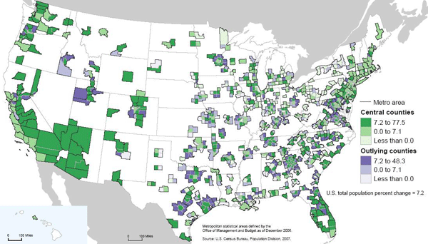
New Geography has just reported that a new Bureau of the Census report has found that exurban growth rates continue to far outstrip urban growth. While this finding might seem somewhat shocking in the face of nascent urbanism upswelling throughout most major midwestern cites and loft developments arising from Salt Lake City to Peoria, the scale at which urban redevelopment is occurring is not and cannot match the scale of greenfields development. The reason should be obvious. It is far easier to sprout houses on 400 acres of farm field without any neighbors or existing infrastructure then it is to assemble a massive urban tract for development. While I will not spend much time discreditingthe author's slant (after all, the reviews of his book on amazon do that quite efficiently), attempting to deliberately ignore these differences in scale in order to deflate the significance of new urban population growth is a cynical manipulation of analysis at best. Positive Population Change for Cities and Outlying Areas.
Whatever the case, many Americans are continuing to seek their dreams in suburban and exurban areas. With the recent onslaught of coverage on suburban foreclosures it is germane to ask what will the suburban landscape look like in half a century? Will foreclosed houses become productive gardens for remaining residents? That possibility, while alluring, seems unlikely without concerted effort and regulation. It is more realistic to assume that the suburbia of the future will look like the cities of the present. With these thoughts in my head I decide to take a walk.
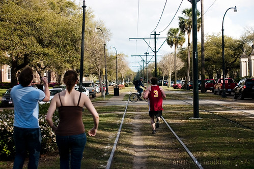
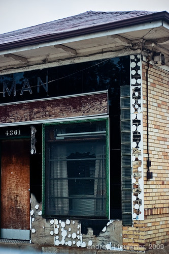
Washington Avenue is one of the significant streets of Saint Louis. It spans almost eight miles with fits and starts, beginning at the riverfront and ending in the streetcar suburb of University City outside the city limits. It is best known as the main artery of the former Garment District which has been redeveloped as a concentration of lofts and restaurants. Further west Washington Avenue (neé Terrace) is one of the most exclusive gated streets in the city. In between these two poles, and just north of the posh Central West End, Washington holds clues to the future of the suburb.
Like many thoroughly urban areas, Washington was once a suburb itself. Extending beyond the limits of city development across a wide area known as the Grand Prairie the development of the street was made possible by a new type of transportation: the electric streetcar. A number of car lines ran nearby, including the #10 on Delmar, the #15 Hodiamont on a private right of way several blocks north, and another line running on Olive from Lindell to Walton. [For the 1910 Map, click here.] Much of Washington was built as speculative development, and as we walk through the intersection of Walton and Washington we will see a perfect example.
4617-4641 Washington Avenue. These two family flats were built as part of a row of eight in 1901. Their lot division, atypically small even for this area, was the result of being near the junction of Washington with Olive and the streetcar line. At the time these flats were built, land value was a direct function of distance from fixed-route public transportation. It was only with the switch to buses and the uncertainty of a potentially variable route that this relation was severed.
Despite alternating brick and stone units, common features such as the placement of the turret and Jefferson windows above the porch tie the composition together. Two units have been demolished and the windowless one is in the clutches of Bowood Gardens, but despite the removal of integral context the power of the alternating repetition still makes for an excellent streetwall. Compare this image mentally with a typical modern suburban street. If every third house was replaced with an overgrown lot, how would it compare with the above image?
Looking at the 1909 Sanborn map of the block it is evident just how much urban fabric the area bounded by Walton, Washington, Taylor and Delmar has lost. All of the red markings denote buildings replaced by vacant lots or parking, the green marks denote buildings replaced by more recent buildings. While I was unable to find any information on it, the loss of the courtyard apartment at Taylor and Washington was tragic. Despite all the losses, the relatively narrow block depths and remaining buildings still manage to keep the block from feeling like a wasteland. With suburban lots typically three to five times wider than these lots, the loss of a single foreclosed house to fire or demolition would have a much more severe impact on surrounding values on the cul-de-sac or road.
I continue walking east on Washington, crossing Taylor and then Newstead. The block of Washington between Newstead and Pendleton has seen some of the most dramatic loss of urban fabric.
While this block has retained the wide-lot platting that belies its upper class origins, most of the original houses have been demolished. On the south side eight remain standing, on the north side only six. In contrast to the suburban style infill built on the south side in 1997 across two lots, the 2006 infill homes by X3 Developers are striking in their competency.
Three infill houses on Washington by X3 Developments.
Built at 4341-4347 Washington to replace three houses dating to the mid-1890's that had unfortunately been lost, these three infill units notably carry the masonry entirely around the building (unlike some recent failures). While the arched windows on 4345 are kitchy and not architecturally appropriate to Saint Louis, the flanking models have a nicely understated referencing of Richardsonian Romanesque. Since these sold for half a million dollars apiece, I feel compelled to note that the hipped roofs are a let down, the tectonics are too flat without more complicated brickwork and the stoop/stair combination is a blatant and unnecessary reference to brownstones over 1,000 miles away. While I would prefer for infill to refer to surrounding structures but ditch the weak historicism like Anthony Robinson's recent projects I would still not be disappointed if they filled in the rest of the empty lots on this block with more considered variations of these.
The true gem on this block is not the new infill, but an old remnant. Service Station at Pendleton and Washington.
This service station was built to replace a mansion sometime in the 1920s to serve the growing motoring demand of the wealthy residents in surrounding neighborhoods. The beautiful black Vitrolite facade probably dates from the 1950s. Note the elegant reveals of glass block at the sides of the facade as well as the combination of green window mullion and chrome. The architecture of this facade displays a confidence not found even in the half million dollar infill houses. At the time of the facade installation this service station was a block away from the epicenter of St. Louis nightlife at Gaslight Square. The decline of Gaslight Square meant the decline of business for this little gas station. It served for a time as the home of Kugman Motors, but it has been vacant since at least 1989.
The block of Washington between Pendleton and Olive has seen much change in the century since the Sanborn Map was complied. The failure of Gaslight Square led to the demolition of the north side of Olive between Newstead and Whittier in the early 1990s. As part of the Gaslight Square redevelopment Pendleton was realigned to connect with Boyle. This ironically eliminated the jog that gave Gaslight Square its name. The two institutions that anchored the block disappeared decades ago. Bishop Robertson Hall was a private Episcopalian school with a 2,000 volume library that closed in 1915. The Episcopalian nuns of the Good Shepard then moved to Baden. The more significant of the two, Hosmer Hall had been established as an elite girls school in 1884. Today it is remembered as the alma mater of poet Sara Teasdale and for infamously banning hair extensions in 1909. A decade after the World's Fair Hosmer Hall moved to Clayton. The school closed and sold their building to Clayton in 1936 and it became known as the Wydown School until it was raised and replaced in 1965 by the present Wydown Middle School.
The final stop on our walk is in front of one of my favorite buildings in Saint Louis. Often I daydream about having unlimited resources to realize any project in the city. While a part of me longs to save and rehabilitate the apartments at 5315 Cabanne, the building at 4005 Delmar, or maybe even the San Luis, only one house calls to me.
4243 Washington.
4243 Washington avenue is unique. For every building in Saint Louis exploding with ornate terra cotta or wrought iron ornament there are many buildings that derive their aesthetic power from restrained geometries that presage the modern movement by decades. In that class 4243 Washington stands out with an unprecedented geometric purity that reinforces its three powerful stories.
4243 Washington.
Built in 1891 on the northern edge of the Central West End 4243 Washington anticipated a density and level of income that was never to coalesce. Unlike the majority of the houses on the block 4243 had three full stories combining for 5,200 square feet on a standard 50'-0"x150'-0" lot. In 1909 it was the only house on the block to have a two story carriage house. It is unclear when the carriage house was demolished, but a garage constructed in 1994 now has taken its place.
By the late 1950's the neighborhood had changed. Upper and upper middle class residents had either retreated into the private streets to the south or left the city entirely. According to a twenty year resident of the block named Lee, during the heyday of Gaslight Square older neighbors recollected Tina Turner stayed with a friend at 4243 when she was avoiding Ike Turner. After the fall of Gaslight Square Lee recollected that there was a lot of crime and prostitution in the area. As buildings burned and were demolished most of the residents left. 4243 survived under the same owner as the neighborhood got quieter and quieter. In November 2003 long-time owner Louise Holland sold 4243 for $125,000. New owners Ralph and Katrina Russell bought the property and began to reahab the house. Unfortunately they lost it in foreclosure in 2007 while in the process of replacing the windows. The empty shell was then sold for $79,000 to a Kevin Settle who sold it to M&J Enterprise for $95,000. The new owners have not paid property taxes since they have purchased the building.
If ever there was a building uniquely suited for a vacant building registry, stabilization, seizure, and resale this is it! However, even boarding second floor windows (let alone tarping roofs!) is "too expensive" despite the far greater economic and environmental costs of demolition. Disregard that: in this city, like in our equally visionary sister city, demolition means jobs.

 St. Louis skyline at night. Photograph by author.
 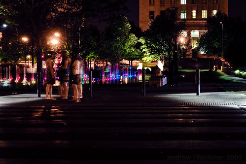 Saint Louis CityGarden -- a project by the Gateway Foundation designed by Nelson Byrd Woltz. Photograph by author.
 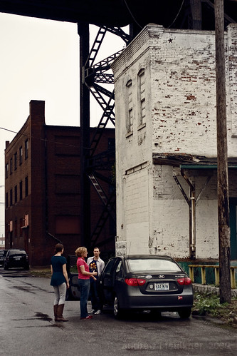 Visitors to the UrbanNexus conference included Sarah Szurpicki of the Great Lakes Urban Exchange and Sharon Carney of the Michigan Suburbs Alliance pictured here with Jeff Vines at Chouteau's Landing. Photograph by author.


