Discovering civic engagement through guerilla urbanism


The current recession was unforeseen by all but the most thoughtful and careful investors, but many effects of the recession are predictable. The average individual has drastically reduced spending in favor of savings as reflected in the downward spike of the Personal Consumption Expenditure metric and the converse increase in the Personal Savings rate to 4.2%; this rate marks an 11 year high.

The primary physical manifestations of these trends include a turn away from luxury retailers to discount superstores, the emergence of the ridiculous "recessionista" trend, and a significant decrease in vacation plans. More interestingly, some cultural pastimes recently relegated to nostalgia are once again becoming popular. One blog lists 67 Cheap Date Ideas for the Recession-Era Romantic. The general flavor of the cultural swing can be drawn from the following suggestions:
Browse the local farmers’ market.
Go on a picnic.
Go apple picking.
Attend an open-air festival.
Attend an art gallery.
Pick up a movie at your local library.
Go window-shopping.
Watch Shakespeare in the Park.
Skip rocks at a lake.
Take dance lessons at a local community center.

Consider what kind of reaction might have been expected to the activities on the above list as few as three years ago. What is striking about these activities is not their affordability, but the extent to which they utilize public space and amenities as the setting for recreation and socialization. It seems that the economic recession has singlehandedly revived the recently moribund concept of public space. In locations where parks, plazas, and playgrounds already exist creative programming can help to attract residents and provide a civic amenity.

Unfortunately in the current situation the funding streams for many of these programs are drying up and beleaguered city and state governments typically do not prioritize civic amenities. However, maintaining such programming to support a civic life has positive tertiary effects on everything from crime to property values. As Noah Kazis argues:
These events are not about “quality of life” in terms of concrete provision of goods or services. These kinds of events are valuable only because they are about building local community, real or imagined. In some places, these events are at the local enough level that you see the neighbors you know and the ones that you should get to know in a friendly environment.
...
Building these communities is important. Community cohesion is important for keeping down crime, for fostering local businesses, for all sorts of things. Intuitively, I think everyone knows that when you walk into a vibrant community, as opposed to just a neighborhood, you know instantly it’s a place you want to be.


The development of a vibrant and civic minded neighborhood is the definition of sustainability. Many important figures have noted that citizen participation is the bedrock of a sustainable pattern of urbanism. Once initially educated on core concepts of sustainability, residents are best equipped to devise and propose new initiatives, and it is this civic engagement that has contributed to the success of significant projects.

Clearly the cultivation of civic engagement and vibrant urban spaces is important. The irony of the current blossoming of interest in urban civic space is that the same economic conditions that instigated this cultural shift also curtail government spending. In the current economic climate quality of life projects unfortunately take a back seat to other more pressing concerns. This does not have to happen. Most civic projects focusing on public spaces concentrate on large visions of redevelopment.

Vibrancy can also be built from a number of inexpensive tactical incisions into the urban fabric. After all, small projects can turn urban space into an urbanism of the scavenger hunt to encourage walking, which in turn stimulates small businesses.

I have gathered five techniques to reinforce public space to inspire everyone to take up the cause of guerilla urbanism. These are presented in order of least to most expensive.

#1: Poster Pocket Gardens.
Artists Sean Martindale and Eric Cheung used the existing posters plastered on building sides and utility poles as a container for public greenery. This method has some promise for an urban-scaled plant sharing cooperative. Sprout extra seeds? Just leave them on the corner telephone pole!
Poster pocket plants in Toronto (via Spacing Toronto).

#2: Crack Gardens.
Although this project by CMG Landscape Architecture was a formal garden design for a residential property, it points to a tactic to be used on crumbling streets and alleys of urban areas. Such gardens could also help to limit stormwater pulses by absorbing rainwater and limiting runoff.

Crack Garden by CMG Landscape Architecture (via Pruned).

#3: Garden Sharing.
OregonLive reports on Alice Lasher and Sue Decker who have begun sharing gardens and trading produce for labor. Their garden extends over property lines and along parking strips by the street. Expanding personal gardens to the neigborhood scale produces community interaction and results in a concrete benefit: good produce from underutilized land.
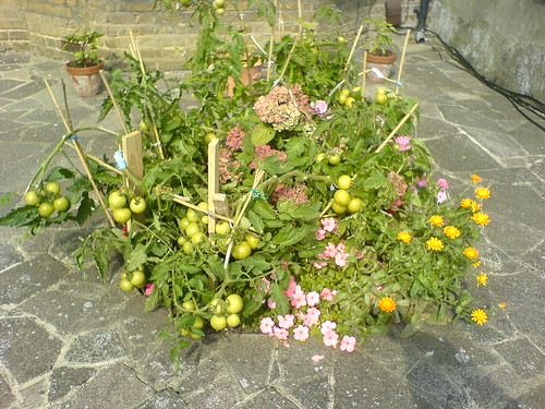
TH - Best Front Garden Produce by szcze.

#4: Temporary PARK(ing).
The Rebar art collective in San Francisco deployed the initial PARK(ing) intervention on November 16, 2005 from noon until 2 p.m. Visitors enjoyed the turf and took turns paying the meter. Since then the phenomena has taken off into a network and numerous deployments have taken place across the United States. While the construction of this type of intervention is moderately expensive, the iconic image and ease of transport make it a great anti-car advocacy tool.
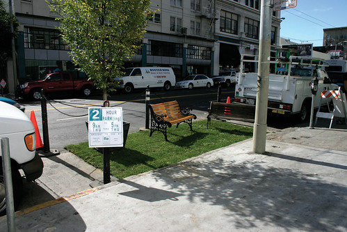
PARK(ing) Project 2005 iteration (via Rebar).

#5: Dumpster Diving.
Reminiscent of a cross between Ken Smith's Dumpster Gardens and the old Situationist slogan "Beneath every paving stone, a beach!", this project by MACROSEA in Brooklyn only took 12 days to build. Like the PARK(ing) project, this concept could be a significant tool to revitalize places with a dearth of public amenities. Furthermore, this project suggests ways to deploy significant civic infrastructure using readily available materials on a small budget.

Dumpsters turned beaches (via ReadyMade).

Streetcar Urbanism in St. Louis: A Proposal


Note: This piece is the continuation of a previous post examining the proposal by Joe Edwards to build a two mile streetcar (neé Trolley) line to connect the Delmar Loop area with the Missouri History Museum and Forest Park.

In the first article I compared the Loop Trolley project to a streetcar project in Columbus, Ohio:

"...the Loop Streetcar connects an already developed area (named one of America's 10 Greatest Streets in 2007 by the American Planning Association) with Forest Park and would run a mere two and one quarter miles. Of this length, only around eight blocks have any potential for the streetcar to serve as a catalyst for significant redevelopment. The Columbus proposal would have been greater than five miles in length, would have connected five distinct economic centers and could have provided the catalyst for over thirty blocks of undervalued property."


My contention is that the Loop Trolley should not be envisioned as a tourist attraction as it is now, but should be understood to be the start of a restoration of an effective surface transit network and as an engine for incremental growth.

"Cleveland’s [St. Louis's] leadership has no apparent theory of change. Overwhelmingly, the strategy is now driven by individual projects. These projects, pushed by the real estate interests... confuse real estate development with economic development. This leads to the 'Big Thing Theory' of economic development: Prosperity results from building one more big thing."
- Ed Morrison, "Cleveland: Reconstructing the Comeback" via The Urbanophile

St. Louis, like many mid-sized cities, represents Morrison's assessments of Cleveland to a tee. The influential industrialists that motivated major changes a century ago are gone. Names like Wachovia have replaced the financial firms that outlasted the demise of industrial powerhouses like the St. Louis Car Company or the American Stove Company. Other powerhouses such as Anheuser-Busch have been sold overseas. As the Urbanophile describes, transactional businesses such as real estate have completely replaced the industrial/commercial ogliarchy of old. Thus, real-estate development is conceptualized as economic development, and the major infrastructural improvements that could drive the development of revitalization and attract the necessary workforce for innovation are sacrificed for strip malls, warehouses, or failed commercial redevelopments.

The political and economic situation bears striking similarities to Paul Collier's assessment on post-conflict recovery:
The first principle is, it's the politics that matters. So, the first thing that is prioritized is politics.

[Development should proceed in the most apolitical way possible. Decisions should be made with the entire city and region in mind, not for one ward at the expense of another or one region at the expense of another.]

And then the second step is to say, "The situation is admittedly dangerous, but only for a short time."

[Development decisions should be made with a view towards fostering sustainable growth and future development, not through short-term job creation and TIF-baiting]

And thirdly, what is the exit strategy for the peacekeepers? It's an election. That will produce a legitimate and accountable government.

[Development (especially infrastructure development) should be freed from electoral cycles and the control of aldermanic discretion]

So that's the conventional approach. I think that approach denies reality. We see that there is no quick fix. The reality is that we need to reverse the sequence. It's not the politics first; it's actually the politics last. The politics become easier as the decade progresses if you're building on a foundation of security and economic development. The rebuilding of prosperity.

Why does the politics get easier? And why is it so difficult initially? Because after years of stagnation and decline, the mentality of politics is that it's a zero-sum game. If the reality is stagnation, I can only go up, if you go down. And that doesn't produce a productive politics. And so the mentality has to shift from zero-sum to positive-sum before you can get a productive politics. You can only get positive, that mental shift, if the reality is that prosperity is being built...

But the objective of facing reality is to change reality.
--Paul Collier "New Rules for Rebuilding a Broken Nation", 2009.
(emphasis and bracketed comments added)

In the interest of changing reality, I will show how extending the Loop Trolley beyond Joe Edwards's vision could begin to act as an economic driver for urban redevelopment and could be leveraged in subsequent phases for future growth.

Phase I: 2015
Changes to proposed route: Light Blue
Beginning with the initial route proposal, I examined the street widths along the route and efficiency statistics from several cities. The Loop Trolley is currently planned to occupy two traffic lanes (two way traffic) on Delmar through the Loop. At this point Delmar is only 48' wide and Loop Trolley planners intend to retain two lanes of street parking. Note that Portland's Streetcar System Concept Plan predicts an average speed of 7 mph riding in traffic. By comparison, a streetcar in a median right of way will typically achieve a speed twice as fast.

In order to facilitate a separated right of way, the streetcar has been routed to run westbound on Delmar, looping around to Kingsland via Loop S. The streetcar would the head north on Kingsland before heading eastbound on the Vernon Ave. Loop bypass and would rejoin Delmar at the MetroLink station (Des Peres Ave.).


View Streetcar Proposal in a larger map

This route would have other benefits beyond merely increasing line speed. The eastbound routing on Vernon follows the #2 Bus and would connect the 1,500 residents in the Parkview Gardens neighborhood with the MetroLink station. This proximity to transit would also spur redevelopment of the underutilized commercial strip along Vernon between Kingsland and Westgate.

Amendments to proposed route: Light Blue
The two major problems with the existing route are that the History Museum is not a strong enough draw for a terminus, and it does not service any major job centers. In the turn of the twentieth century streetcar companies addressed this issue by building amusement parks at the end of their lines to draw more traffic.

To solve this problem, I proposed extending the route on Delmar to the Central West End and looping around the West End. While the Olive streetcar originally ran in a zigzag west from McPherson to Waterman (at Kingshighway) to Pershing (at Union), Delmar is an excessively wide boulevard with ample width for two dedicated and separated tracks.
The CWE loop would take advantage of the wide median on Kingshighway to loop south to Laclede (within easy walking distance of the Barnes Jewish/Wash U/Children's hospital complex) and then continue on Buckingham (reversed one way from present) to North Ct./York Ave. and then through the heart of the CWE on the old Maryland #12 Streetcar ROW. The loop would then follow that ROW left on Boyle and turn westbound at Delmar.


View Streetcar Proposal in a larger map

Besides connecting an estimated 26,000 employees at the hospital with numerous commercial businesses in the Loop and the CWE, this alignment would provide a major impetus towards redevelopment on the north side of the CWE. Over 14 blocks of underdeveloped land would see an increase in value and the streetcar would provide considerable assistance to redevelopment efforts in the former Gaslight Square area. This route, around seven miles in length, would require more route investment, but would not require additional carbarns or maintenance areas. Such an extension would drastically increase boarding and would secure the viability of the Loop Trolley proposal.

Phase II: 2020: Green
Pending successful operation of the Delmar Loop/Central West End, an expansion could be easily planned along the former Olive St. ROW and McPherson/Washington. This expansion would be a compact figure eight meant to connect the Delmar Loop/Central West End with the museums and entertainment facilities in Grand Center. The figure eight would run as a spur from the CWE route during designated hours. The estimated time on the extended original line from City Hall in University City to the Fox theater would be 25 minutes.

At the same time construction would begin on the reinstallation of the #70 Grand streetcar line between a loop opposite John Cochran VA hospital to a loop just north of Grand and Gravois. This section would completely follow former streetcar right of way and be able to run in a dedicated median as a result of the wide street width.


View Streetcar Proposal in a larger map

This route would replicate one of St. Louis's most used streetcar routes and would connect the VA Hospital with Saint Louis University Hospital, and the cultural institutions in Grand Center with the populations of both University City and the near south side. The CWE extension could bring more redevelopment on the eastern fringes of the Central West End and both routes provide valuable support to the nascent efforts of the Locust Business District.

Phase III: 2025: Yellow
Phase III would include a Washington Avenue/Olive Street line that would run from the Blue line loop east of Grand through the loft district to Laclede's landing and the Arch MetroLink station. In addition, a new line would be built running south on Florissant from Palm St. through downtown on Tucker with a connection to the 14th St. Greyhound/Amtrack/MetroLink station, and south on Gravois to Grand.


View Streetcar Proposal in a larger map

The Washington/Olive route would provide economic support for the underdeveloped areas between Grand Center and the Loft District and would integrate the faltering entertainment district at Laclede's Landing with downtown institutions such as the Convention Center. The Florissant/Tucker/Gravois route would connect some of the most densely populated areas of the city with jobs downtown and with other necessary amenities while spurring redevelopment in St. Louis Place and integrating Old North St. Louis with downtown.

Phase IV: 2035: Purple
Phase IV would include an extension on the #70 line north from the VA Hospital to N. Florissant Ave, an extension south on the Gravois line from Grand to Germania St, and a line on Natural Bridge from the UMSL South MetroLink stop to Palm and North Florissant.


View Streetcar Proposal in a larger map

These routes would leverage existing streetcar routes and would connect with existing transit corridors. Furthermore these routes would tap into dense population centers in the city and would facilitate small scale economic and storefront redevelopment.

Phase V: 2050: Brown
The final planned phase would consist of three lines along former streetcar routes. A Goodfellow/Union/Hampton line would connect from the Riverfront transit center to Forest Park and the end of the Gravois streetcar in far south city. A Martin Luther King/Cass Avenue streetcar would provide an East/West connection on the near north side from the St. Charles Rock Road MetroLink Station to downtown. A Broadway/Chippewa line would connect the Cass Ave. line through downtown/Soulard and south city to the Shrewsbury MetroLink station. While it is too far in the future to prognosticate development potential, this line could provide a great development impetus to the neglected industrial land along the south riverfront.


View Streetcar Proposal in a larger map

While this was an intellectual exercise, it emphasized some key lessons. First, any proposed transit as expensive as a streetcar line must serve a vital connection need and must connect key employment destinations. Cultural destinations are important draws, but major employers are vital. Secondly, while there are parts of the city that suffer from a lack of transit, the best route is an already successful route. More revenue upon opening will provide a greater impetus to expand the system. Finally, due to the era of development in St. Louis, the built environment and infrastructure was specifically designed for streetcar-based transit and a considerable amount of infrastructure remains to this day. Therefore, implementation is not as difficult as in other cities.

For other route proposals look here and here.

The heights of irony: protecting our children in a "ClusterF**k Nation"


There was recently an interesting article on anti-urban media bias from Greater Greater Washington, a blog focusing on urbanism in Washington DC. Dissecting the Washington Post coverage of Fairfax County Virginia's proposed incorporation as a city, the blog emphasizes how the article's authors repeatedly use codewords for city such as "blight" and "crime". Furthermore, they revealed their biases in an illustration of the difference between a city and a county through an explanation
"which juxtaposes suburbs ‘where Washington goes to walk the dog and water the lawn’ with something ‘many have tried to avoid: high-rise offices, blight, crime and housing that's more likely to have a balcony than a back yard.’"
.
While this is an egregious and perhaps malicious example of anti-urbanism in reporting, many other examples can stem from overly sensational reporting or from the natural biases caused by a set lifestyle. For example, since reporters presumably represent an average cross-section of the american population, it is not unreasonable to assume that few reporters walk or bike to work. Thus, the act of driving colors their view of the world and that coloration inevitably seeps into their writing.

There are, however, some stories that are so ridiculous as to overwhelm whatever personal urban or anti-urban bias a reporter might have. The events of May 15th in Saratoga Springs, New York are one such event. Andrew J. Bernstein reports the events occurring on National Bike to Work Day:
Janette Kaddo Marino and her son, Adam, 12, wanted to participate in the commuting event, so the two set off to Maple Avenue Middle School on bicycles May 15. The two pedaled the 7 miles from their east side home, riding along a path that extends north from North Broadway straight onto school property.

After they arrived, mother and son were approached first by school security and then school administrators, who informed Marino that students are not permitted to ride their bikes to school.

“Unbeknownst to us there is a policy,” she said, “but it wasn’t in any of the brochures given to us.”

School officials took her son’s bike and stored it in the boiler room. They told her she would have to return with a car to retrieve the bike later in the day.

I will ignore the possible legal ramifications of illegal seizure of private property and examine the school environment. Maple Avenue Middle School, like the vast majority of educational facilities in the country, is built on the periphery of Saratoga Springs. While this location presumably made consolidation easier and facilitated a larger athletic complex, it put it out of easy reach for the majority of students.


Maple Avenue Middle School in relation to Saratoga Springs.
View Larger Map


Maple Avenue Middle School aerial.

The school was built in 1992 on busy US Route 9 (Maple Avenue--bucolic in name only) to facilitate bussing students not only from the city, but from the suburban developments ringing the former resort town. Two years after the school was built the school district issued Transportation policy No. 741 forbidding students to ride or walk to the school.

The school was designed to accommodate 1,800 students (in a middle school-- that averages to around six hundred students per grade!) divided into four sub-sections, each named for one of the Saratoga Springs Lakes. The school, from the aerial is all but indistinguishable from a minimum security prison and the urban design reinforces the idea of containment. There is no clear path to the entrance and the school sits nearly a hundred feet back from the road behind parking lots. Route 9 is atypical of high-traffic rural routes, despite being an undivided two way road, it does have ample shoulder room at least a lane wide. This is immaterial however, the route Mrs. Marino and her son took was on a quiet neighboring street that dead-ends into the school property.

The principal, one Stuart Byrne, explained that the prohibition on self-transportation to school is, of course, designed to protect students:
“I would be a nervous wreck every day if kids were riding to school,” he said. “Traffic isn’t bumper to bumper, but it’s non-stop. He said the district’s policy does not allow students to ride or walk to schools outside of the city’s urban core.

While traffic is one concern, Byrne said he also worries about children traveling unsupervised through the community. He noted that students are under school supervision until they are dropped off by the bus or picked up at the end of the day.

“If you look at the North Broadway route that the parent used that day: (Even if) there were going to be some exceptions or monitoring (to allow riding to school), you’re still going into a substantially wooded area,” he said. “I don’t know how you say to the community at large that is a safe area.”

In one statement the principal has raised every parental boogeyman from traffic accidents and abduction to fear of the wild to substantiate the need for continuous monitoring and control.

Of course, the public health implications of policies that prohibit walking and riding are not considered. According to Dr. Richard Jackson, one third of children born in the past year will contract Type II Diabetes if current trends continue. The Centers for Disease Control just reported that the rate of clinical obesity in adults in the United States has hit an all-time high: 26.1 %. Type II Diabetes causes an average of a 15 year reduction in life span and considerable related health problems. Today diabetes costs the US medical system $218 billion dollars annually. If Jackson's prognostication holds true that cost will rise by one hundred and fifty times by 2059 to $32,700,000,000,000. Can our nation afford that cost?

There is a solution. Jackson points out that walking more than 10,000 steps a day (roughly 4 miles) helps diabetics control blood glucose levels and prevents the onset of Type II diabetes.

This brings us back to upstate New York and Maple Avenue Middle School. While nearly 60% of students walked to school in 1973, now only 13% do. Undoubtedly, while many children can no longer walk or bike to school due to ill-conceived sprawling and car-oriented communities and the growing trend of school consolidation, it is also worth asking whether misguided policies shaped by our overly-litigious society and over protective attitudes prevent another segment of the school-age population from living a more healthy way of life.

Mrs. Marino has not given up. She has biked with her son several times and, as of 9 June was petitioning the school district to join the Safe Routes to School Program.


The ironies to this story are many. To begin with, the photograph above shows that, despite Transportation policy No. 741, there is clearly a crosswalk in front of the school that appears to connect to a well used path. Whether a cross-walk on a two lane country road without a traffic light or a stop sign is an invitation to frogger is an open question. Secondly, Kaid Benfield of the Natural Resources Defense Council notes that Saratoga Springs was commended only a week ago by Business Week for being an "anti-suburbia" where "you can walk to work and shopping".

In a greater irony Saratoga Springs is, of course, the chosen home of anti-sprawl post-peak oil zealot James Howard Kunstler. [As a side comment I have always wondered how he rationalizes living in a town of 28,500 with a tourist-based economy that will inevitably be disconnected from all markets and even workshop-based industry if the future is as dire as he predicts.] In any case, Kunstler has yet to acknowledge the story brewing in his own backyard.

UPDATED - Streetcars: things just ain't what they used to be


There has been much consideration and discussion here in Saint Louis about Joe Edwards's plan to reintroduce a streetcar on Delmar Boulevard. The conversation here has been the duplicate of a similar debate raging in my birthplace of Columbus, Ohio. In the case of Columbus, financing was never fully established and that uncertainty, combined with the economic downturn, led to the project being put on indefinite hold.

There are some major differences between the proposals for streetcar lines in Columbus and Saint Louis. In Columbus, the effort was led by a task force formed by the mayor. In Saint Louis, the impetus has come from a private developer, Joe Edwards, who has been the key player in the incremental revitalization of the Delmar Loop. In this case the politicians involved seem to have caught trolley fever and were extremely disconcerted to learn that even in Portland fares only make up 16% of total funding. While this is not earth-shattering if you consider streetcars another form of transit (streetcars pay a larger percentage through revenue than interstate highways for example) but troubling if this is envisioned as merely a novelty.

More tellingly, the philosophy behind each proposal has been different. The lines in Columbus were conceived to connect the 40,000+ population at Ohio State University with jobs downtown and the entertainment and nightlife destinations in the Arena District and Brewery District. The initial plans also involved connecting Columbus State Community College and the Columbus College of Art and Design. As Mayor Michael B. Coleman stated:
I think connecting the Ohio State University to the Brewery District, and the Arena District to the Discovery District, which is CCAD area and Columbus State, is something I think will add to the value of the city, and will be an element of the quality of life to young professionals finding Columbus as a place they want to stay. And anywhere that streetcar is located, you will see restaurants, retail, offices, and residential, all along the line. It will be the spur and difference-maker for economic development in our downtown, in addition to getting around. So it’s a huge catalyst for vibrancy, a huge catalyst for economic development, and a huge catalyst for just getting folks around…

In comparison, the Loop Streetcar connects an already developed area (named one of America's 10 Greatest Streets in 2007 by the American Planning Association) with Forest Park and would run a mere two and one quarter miles. Of this length, only around eight blocks have any potential for the streetcar to serve as a catalyst for significant redevelopment. The Columbus proposal would have been greater than five miles in length, would have connected five distinct economic centers and could have provided the catalyst for over thirty blocks of undervalued property.

The difference is stark, and it is clear that the proposed Loop Trolley (just the use of the term trolley instead of streetcar makes it clear it is planned solely around nostalgia) is meant entirely as a tourist attraction rather than as real transit. This is dangerous for two major reasons. First, as a tourist vehicle, it is especially susceptible to bad publicity. People tend to act much more strongly to entertainment and non-vital establishments once a problem has occurred. Compare the shopping malls to grocery stores; non-essential venues such as shopping malls are exceedingly susceptible to bad publicity. A failure of the Loop Trolley could set back surface transit in Saint Louis for thirty years to come. Furthermore as commenter "Adam" noted at Saint Louis Urban Workshop the brevity of the line is a huge liability in terms of operational sustainability :
When you build only one line, that one line has to absorb all the overhead for operating a streetcar system. It has to have a carbarn; it has to have the electrical substation; it has to have a dedicated trained staff to drive them. And, perhaps worst of all, if there's only one line, it has to be completely shut down for any street maintenance instead of being able to shunt around maintenance on an alternate line. Look at a map of most major cities, including St. Louis, before World War II. Streetcar lines ran up and down practically every major street. They didn't cost $30 million for one mile because resources were shared across many lines (also because labor was cheap). Frankly, $30 million for a single mile along existing streets is absolutely absurd. That's more than $5000 per foot--unless the rails are made of truffles, what is costing that much?

Setting aside the majority of these concerns, how could the proposed streetcar be improved?

It is clear that the trolley backers have not studied the ways trolley traditionally functioned in their proposed study area. A few design changes would have a great impact in recreating a successful streetcar urbanism and increasing safety along the route.

Loop trolley - conceptual rendering.

Looking at the conceptual rendering it is evident that the streetcar is proposed to run in the traffic lanes of already-congested Delmar Boulevard. While running the trolley in traffic lanes romantically hearkens back to the big city urbanism we know from grainy footage, by the time neighborhoods like the Delmar Loop were designed, it was clear that headtimes and safety were improved by separating surface transit from cars.


As this undated image shows, the handicap of streetcar systems is its general inability to detour in the event of accidents

The lushly landscaped boulevards we know today were a design response to this issue. Instead of running in traffic lanes, the streetcars were given a dedicated right of way in the center of the street. In some cities streetcar actuated traffic lights stopped cross-median traffic. The result was increased safety and efficiency for surface transit.


Video from separated ROW of Illinois Terminal Company interurban streetcars, Venice, Illinois.

Former streetcar right of way, now landscape in median, Wydown Bvld..

While not every potential streetcar route has enough width to support a separated system (streetcars typically need at least eighteen feet for unidirectional service) many of St. Louis's boulevards are in excess of 54' in width and some, such as Gravois are in excess of 75' in width. Additional space can also be made on streetcar arteries by limiting parking. Currently Delmar between Kingsland and the Wabash (metrolink) tracks has two lanes of parallel curb parking, two traffic lanes, and a continuous center turn lane (known as a "suicide lane"). The street width from the Wabash (Metrolink) tracks to the end of the line is approximately 48' from curb to curb. In this instance it would make sense to split the line and have one direction loop to the north using Vernon Ave. to avoid overly crowding Delmar and drastically reducing system efficiency.

East of the Wabash tracks the situation is far different. Both Delmar and DeBaliviere have ample street width due to their conscious planning for transit in the early 20th century. The street width is 75' on Delmar and 72' on DeBaliviere allowing in both cases for two dedicated tracks in the median and four traffic lanes with bike lanes or expanded sidewalks on either side. To get an idea of how a revised Delmar streetscape might appear we can look to St. Charles in New Orleans.

Neutral ground on St. Charles Ave. at Calhoun St., a transit right of way and pedestrian refuge.

St. Charles Avenue in New Orleans falls roughly between Delmar Boulevard and Gravois in street width. However, due to the streetcar right of way the street is humanized to a much greater extent. Please also note the picture above was taken in the midst of rush hour gridlock and shows how the neutral ground can create a space for recreation while diminishing car/streetcar contact and greatly increasing system efficiency. Such a right of way could also be flanked with bike lanes to increase efficiency.

In future posts I will propose realignments to the Loop Trolley route as well as future expansions, and examine the often overlooked urban design traits and infrastructure that enabled streetcar-based transit to be so successful, and assess what lessons we may learn from these examples to apply to the revitalization of our cities.

7.9.09 UPDATE:
I was unable to attend the forum on the Loop Trolley, but the presentation is online here:

Alex Ihnen, as usual, has thorough coverage at his blog.

I left the following comment:

While the added expense of running the trolley in the median is certainly an important consideration, I am concerned there is no conceivable way the Loop Trolley will be able to maintain efficient service competing with traffic on Delmar in the Loop during peak hours without separation. Note that Portland's "Streetcar System Concept Plan" (http://www.portlandonline.com/transportation/index.cfm?c=46134) expects an average speed of 7 mph riding in traffic as compared with 15mph in a median right of way.

If lanes are used, there should be a one direction bypass such as Des Peres/Rosedale/Vernon/Kingsland because any accident on the Loop with current levels of congestion would shut down the entire system. Ideally it would be best to limit street parking to one side and remove the continuous center turn lane. While politically divisive this would only eliminate around 100 parking spaces which could be accommodated in future development. The implementation of the Loop Trolly is a serious commitment to transit and should not be hindered by the automobile preference that currently dominates the region.

Independence Day


July 3rd Fireworks in St. Louis.

On this Independence Day as we gather with family and friends to remember the birth of our country, may we not forget the bravery with which they took their convictions and formed an unprecedented union. May we find the same bravery in manifesting our convictions and working to actively prevent irreversible climate change, in challenging outdated ideas motivated solely by profit, and in working to include all our communities in societal scaled solutions.

For as the lesser known versus exult:
America! America!
God mend thine every flaw,
Confirm thy soul in self-control,
Thy liberty in law!
...
America! America!
God shed his grace on thee
Till selfish gain no longer stain
The banner of the free!


or as Langston Hughes wrote (as already I have already quoted on this blog)

"O, let America be America again--
The land that never has been yet--
And yet must be"